Watch a demo
How to design a PV plant with topography restrictions
Mario Bennekers

Content
Utility-scale solar photovoltaic (PV) plants have typically been built on flat, open spaces with minimal variation in the land’s topography. Making simulation and design at the project development stage relatively straightforward. But as demand for solar energy rises, projects are being developed in areas where uneven topography and smaller sites can present challenges.
Variations in topography can reduce the usable land area and cause shading on solar panels that results in lower energy yield and lost revenue.
How do solar developers take topography into account when designing projects to ensure maximum efficiency? And how can they analyze site typography to get the best results?
The importance of topography in solar plant design
Scoping out the terrain of a potential project with a site survey is essential to determining whether it is feasible for solar panel installation in the first place. Some developers have started project development without visiting a site, only to find that the land is not suitable for placing solar panels.
While data from Google Earth and other Internet-based sources can provide first impressions about the elevation of a piece of land, it does not provide information about the quality of the soil. Some areas can have a mixture of soil and rock that does not show up on maps and makes it difficult to directly hammer the piles of the mounting structures, which is the most cost effective solution.
If the soil is not suitable for directly hammering the piles, boring a hole in the ground and making a concrete foundation for the pile, or any other solution, can extend the time it takes to complete the project and push up costs beyond the budget.
Uneven terrain can require grading that similarly increases costs and causes project overruns. And if there are areas of the land that cannot be used at all the plant will end up with a smaller capacity than planned, which would alter the project’s economics.
In that way, a site’s topography can make the difference in whether or not a project will be profitable and worth pursuing.
Topography is something crucial also when doing solar yield estimates, as the shadow that structures or trackers project in between them can have a huge impact on the final result. Many manufacturers are providing intelligent tracking algorithms that take into all this affection to decrease the impact of this effect.
Analyzing topography manually
To scope out a site manually, the first step is to visit the site to take photographs and carry out a topographical survey. This can be done with GPS and other topography stations, or data collected by flying drones over the site.
Designers can also make use of general elevation databases like the Shuttle Radar Topography Mission (SRTM), which is an international project led by the US National Imagery and Mapping Agency (NIMA) and NASA. In some countries such as Spain, the national geographic institutes collect detailed elevation data that can be downloaded and input into a CAD software program such as AutoCAD.
Technical analysis of the ground is key to not only understanding the type of soil, but also the drainage on the site, to be able to remove all the water and ensure the plant will not flood once installed. In rainy areas, flooding can cause damage to panels and limit the usable area of the site.
Placing the structure of the plant can be done manually with an Excel file that analyzes how the structures fit the ground, although that can be a time-consuming task, as moving any part of the system means re-checking every other structure. Using Excel also allows designers to insert formulas to partially automate these adjustments.
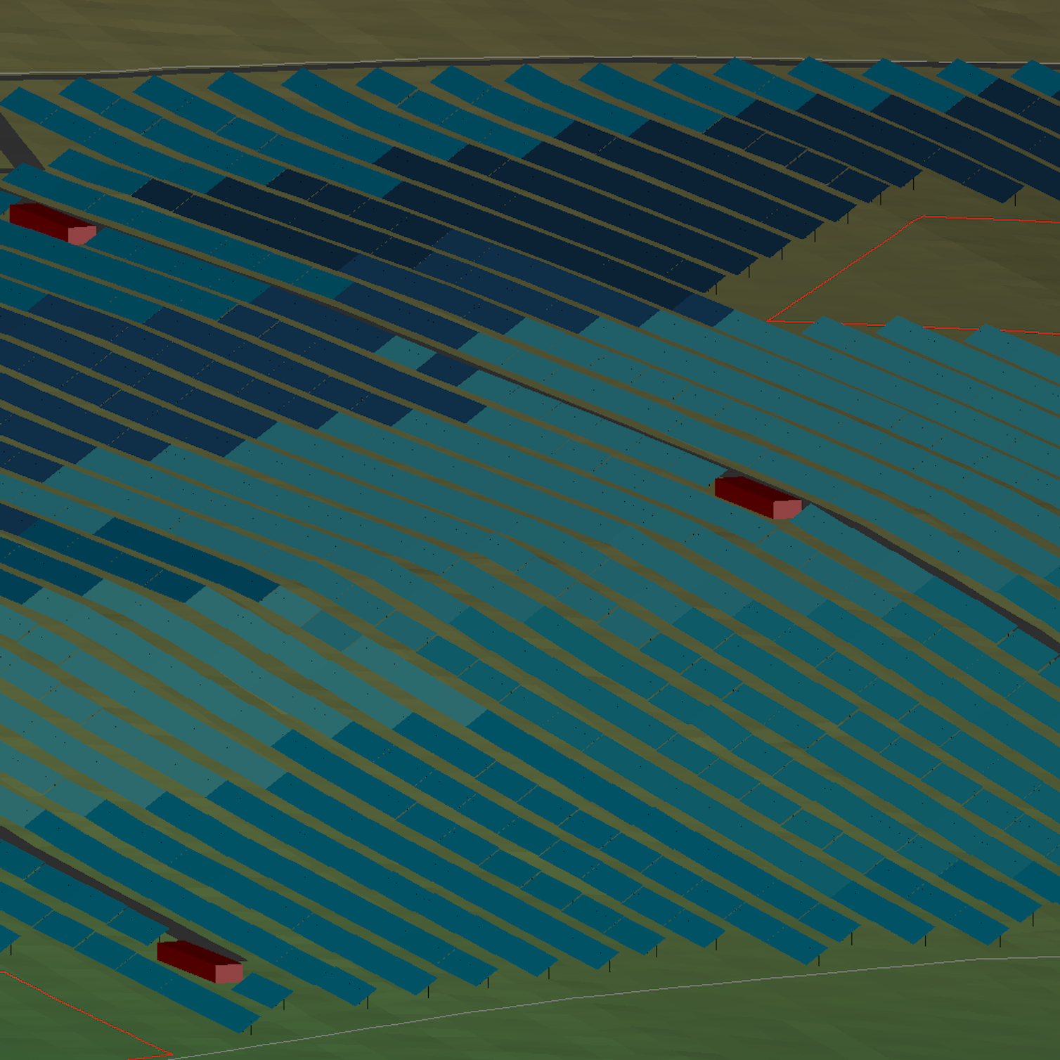
Automating topographical analysis
Algorithms in Excel can analyze topographical data automatically, replacing some of the manual tasks. They can help identify when a structure fits or not in the ground based on different criteria or restrictions like slope or post length.
Taking automation a step further, solar software like RatedPower platform can optimize all the elements of a site design automatically, running calculations within minutes that could take days to do manually.

Check RatedPower software's methodology on topography analysis. Download it today!
Full automation makes it easier to determine how much grading is needed to use the land and check the limitations of various layouts. Designers can analyze the effect of installing trackers on north-south slopes or in the east-west direction. They can also set the criteria the structures will need to deliver peak power, to see whether the installation is feasible based on the terrain.
By using automatic tools, project designers can compare hundreds of scenarios and get an idea of the true cost of a project, taking into account the preparatory site works that will be needed to get the terrain in the optimal condition for solar panel installation.
Automation brings together topographical analysis with technical economic analysis, identifying not only how feasible it is to do the work, but also whether it can be done within the project’s budget. Having all the data to make better decisions in one place is a true game changer for solar plant design.

Choose RatedPower for detailed topographical analysis
Challenging site topography need not derail a utility-scale PV project. Software automation can optimize the layout of the site to generate the most power while saving time and money on costly adjustments to the terrain once the project is underway. This increases project profitability and makes it possible to develop installations on land that may not have seemed suitable in the past.
Contact RatedPower to find out how our platform can automate the topographical analysis for your solar project site.
Latest stories
Related posts
Technology and engineering
How 3D Planning Is Accelerating Solar Deployment in Finland
Find out how 3D solar design and digital permitting are transforming Finland’s energy development, streamlining workflows, and ensuring regulatory compliance.
Updated 24 MAR, 26


Technology and engineering
Outsmarting congestion: How efficient solar design helps navigate Nordic grid limits
Learn how Nordic operators and solar developers are adjusting to tighter grid conditions and how policy and design decisions are keeping projects on track.
Updated 16 DEC, 25

Technology and engineering
The rise of ultra-thin perovskite solar cells
Learn about Japan’s $1.5B initiative to commercialize ultra-thin, flexible perovskite solar cells and how it could transform the solar landscape globally.
Updated 30 SEP, 25