Watch a demo
Goodbye guesswork with automated earthwork calculations
Automated earthwork calculations flag costly grading risk before construction. See real project savings and get RatedPower's calculation methodology.



Jeremy Vickerman
Senior Content Manager
Senior Content Marketing Manager at RatedPower with extensive experience in content strategy, production, and communications. Over a decade of expertise spanning marketing, recruitment consulting, and public relations across the UK and Spain, with a strong track record in driving brand visibility and audience engagement.

Content
- See constructability before detailed engineering
- Identify slope limitations earlier
- Work with pile-level grading logic
- How does RatedPower calculate cut and fill automatically
- Find construction hotspots
- Review the modified terrain profile
- Reduce contingency by replacing broad assumptions
- Automate your earthwork calculations and reduce your civil costs with RatedPower
Automated earthwork calculations use terrain-aware software to test PV layouts against real elevation data before construction, flagging grading requirements early. By calculating pile-level cut-and-fill volumes and mechanical tolerances during design instead of after, teams can identify slope-related civil cost risks while there's still time to change the design.
Could your PV layout be hiding a very expensive grading problem?
According to estimates, it can cost as much as USD $2.5 million at current civil rates to cut and fill over 500,000 yd³ (382,277 m³) of earth on a 200 MW alternating current (AC) project with difficult terrain. That doesn't yet include subsurface surprises and weather delays.
See how tracker-level grading turns raw terrain into reliable earthwork volumes, costs, and constructability insights before detailed civil design begins. Watch RatedPower's on-demand webinar: Redefining earthworks: tracker‑level grading for buildable PV plants with Natalia Opie to compare sites faster and design more confidently.


This preventable compromise often happens when development teams don’t have access to early-stage tools that can connect terrain analysis directly to layout design. Without that early feedback, they have to blindly pre-decide row positions and electrical assumptions before fully analyzing the land. Row spacing decisions made during pitch distance calculations directly affect how much grading a layout will require, which is one reason civil and electrical assumptions can no longer be finalized in isolation.
That backward sequencing might have been good enough when the majority of solar plants were built on flat ground, but it has become counterproductive now that most projects are assigned to marginal sites. All the regrading required bloats civil costs and can often derail schedules. Reshaping too much terrain can also create drainage and erosion issues that make the project harder to operate over the long term.
How do you flag slope and earthwork risks during early-stage design, when adjustments cost significantly less to make?
RatedPower’s upgraded earthworks engine embeds civil constraints directly into the layout process, so you can see which row placements will likely demand significant grading. Book a demo to find out more.
See constructability before detailed engineering
The problem with conventional early-stage terrain screening is that it relies on average slope (which can mask localized terrain issues) or binary slope thresholds (which can overcorrect in one area and miss grading hotspots in another).
RatedPower gives you a more granular view by testing your tracker geometry against the terrain early in layout design. Instead of screening the site by generalized slope zones, RatedPower helps identify which areas are suitable for the proposed layout based on the selected design constraints and where grading or design changes may be needed. This builds on the same terrain-aware logic behind RatedPower's PV plant topography design, using real elevation data instead of one-size-fits-all slope assumptions.
Identify slope limitations earlier
In utility-scale solar, seemingly minor terrain anomalies can compound and lead to expensive late-stage problems:
● Pile-height differences.
● Irregular reveal heights.
● Installation delays.
● Higher civil costs.
To help you identify these slope-limit conflicts early on, RatedPower applies the mechanical constraints of your selected mounting system directly to the layout.
For single-axis trackers, these parameters can include:
● North-south structural axis limits such as torsion tube slope.
● East-west slope thresholds such as row-to-row grade.
● Directional slope limits.
● Terrain undulation limits.
When a tracker exceeds your selected limits, RatedPower flags it immediately and either: (1) calculates the grading needed to bring the structure within tolerance or (2) removes the violating structures from the layout. Which path applies depends on the direction of the violation. Depending on the direction and nature of the violation, RatedPower can either estimate the grading required to bring the structure within the specified tolerances or remove non-compliant structures from the layout.
Work with pile-level grading logic
Unlike traditional platform-level grading that estimates earthworks by cutting your site into big and flat virtual blocks, RatedPower evaluates the terrain point by point along the tracker structure. This shows whether the hardware can stay within the limits you’ve defined:
● Pile depth (required embedment below grade).
● Reveal height.
● Structural slope limits.
● Mechanical tolerances.
Piling earthworks now also covers Terrain Following Trackers (TFT), extending the same pile-level workflow beyond single-axis systems. You can compare single-axis tracker and TFT layouts side by side to see how earthworks requirements differ, then review and export the updated TFT design directly from your project.
Does the terrain stay within those limits? The model can preserve the natural grade
Does it exceed those limits? The engine calculates the cut-and-fill needed to bring the structure back within tolerance. These mechanical tolerances vary by hardware, which is why choosing the right PV structure for your terrain has such a direct impact on your budget.

How does RatedPower calculate cut and fill automatically
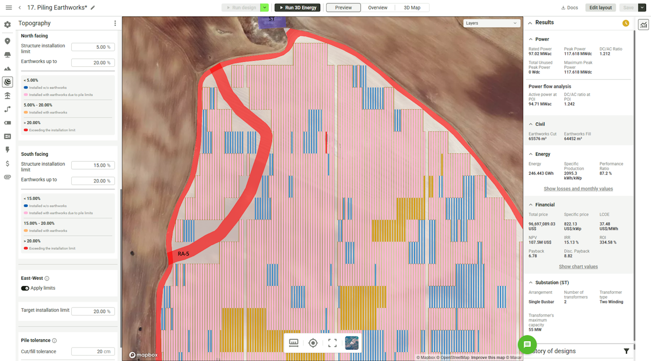
Once RatedPower flags the structures or pile locations that need terrain correction, it calculates cut-and-fill volumes based on your selected inputs. Having these earthwork quantities available early means you can compare several versions of the layout:
Should you limit grading? Consider pulling trackers away from rough terrain to reduce civil costs, even if that means giving up some direct current (DC) capacity.
Should you recover more buildable area? Use the cut-and-fill estimate to decide whether rougher sections are worth grading back into the layout.
Should you adjust spacing instead of grading? For fixed tilt structures, RatedPower can automatically vary pitch distance row to row to fit the terrain within a shadow-free generation window, cutting shading losses without extra earthworks. Minimum and maximum pitch limits keep the result within your construction and land-use requirements, and the resulting ranges carry through to your Design Report, Energy Yield Report, and Project Sheet.
Where does the extra grading stop paying off? Price the extra cut-and-fill, then check whether the recovered capacity pays for it.
Find construction hotspots
Total cut-and-fill numbers show volume but not difficulty. Grading 40,000 m³ of loose soil on a flat site is easy. But are you hauling that exact same volume out of a steep ravine? That will change your equipment requirements and cycle times completely.
This is why the location of cut and fill is just as important as the total earthwork volume. RatedPower generates heat maps that show where terrain corrections are concentrated across the layout. It can:
Show which parts of the site require cut, which require fill, and which require no correction.
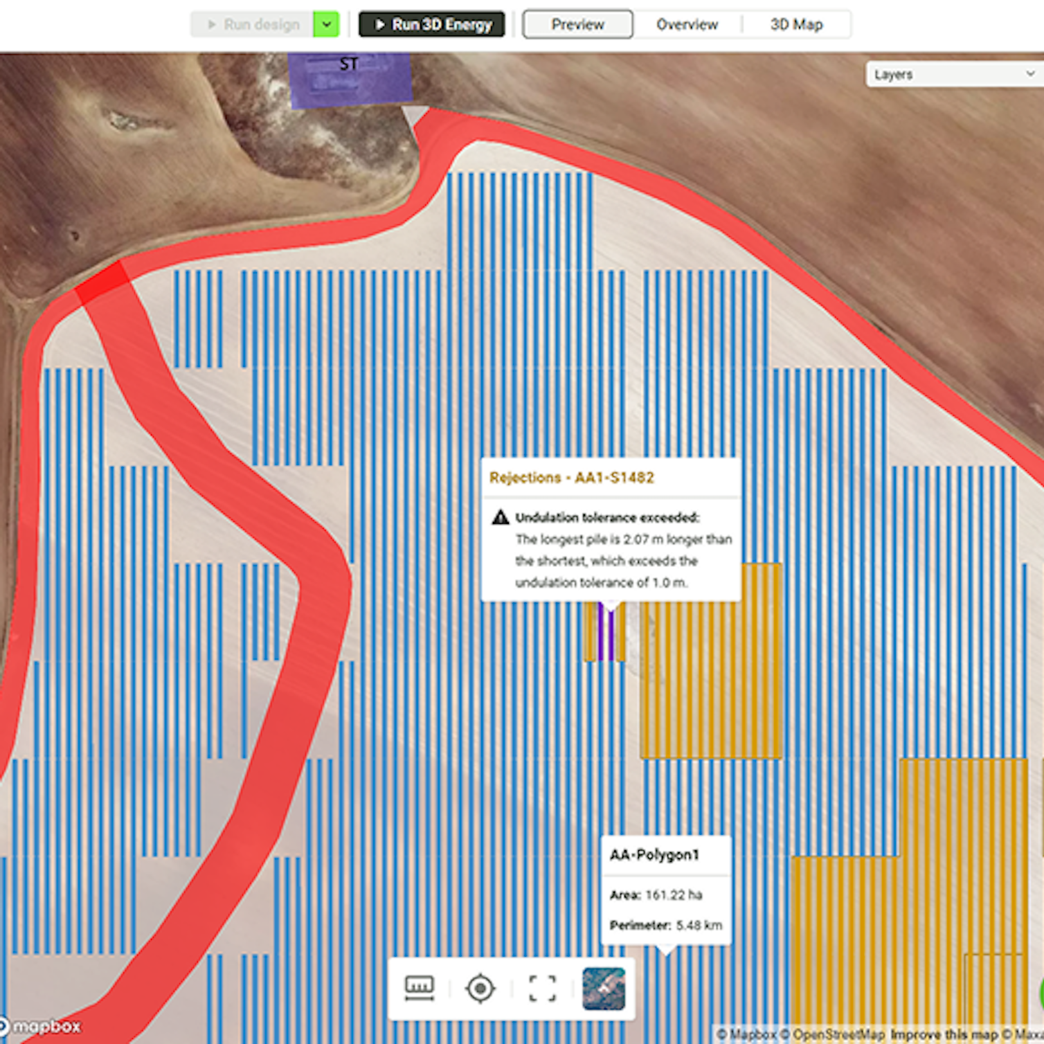
Color-code individual trackers to indicate why they may require grading (especially those that pass general slope limits but still fail internal pile tolerances).
You'll see if grading will likely localize in a few high-risk zones, because those hidden clusters will profoundly affect your construction schedule and budget.
Review the modified terrain profile
RatedPower compares the original ground level with your new design to help you visualize how your grading plan changes the site:
Longitudinal profiles - See terrain variations along the tracker axis where slope and pile tolerances can create tracker binding or structural compliance issues.
Cross-sections and contours - Visualize how your earthwork plan cuts across the entire site layout.
Topography analysis views - Catch isolated terrain hotspots that don't show up in your overall cut-and-fill volume averages.
Reduce contingency by replacing broad assumptions
If you rely on simplified terrain models, you may be forced to pad the budgets with larger capital expenditure (CAPEX) contingency buffers to cover all the unknowns.
RatedPower helps reduce reliance on broad assumptions by quantifying potential civil risks using project-specific terrain data by pulling project-specific terrain data directly into your initial layout. Your finance teams can then use the data to build a more informed cost baseline before you sit down to negotiate contracts.
Automate your earthwork calculations and reduce your civil costs with RatedPower
Early design phases always involve a trade-off between civil costs and capacity. If you prioritize minimal grading to keep civil costs low, you have to follow the native terrain, which restricts where you can place trackers and reduces your total system size. But if you grade aggressively to maximize capacity, your cut-and-fill volumes can quickly escalate and drive up your initial CAPEX.
RatedPower helps teams evaluate trade-offs between grading requirements and capacity during layout design while you’re still building the initial layout, so you can reduce the risk of unexpected earthwork-related costs affecting project economics later in development.
We’re constantly improving the workflow beyond the current engine to make it even more useful. Areas currently being explored include:
Smoother transitions between modified grading surfaces and surrounding natural terrain.
Custom cut-and-fill balance controls.
Including internal access roads in earthworks calculations.
Want the calculation logic behind these results? Get RatedPower's topography analysis methodology to see exactly how cut-and-fill volumes and slope tolerances are calculated.
These future improvements are still in development, but the upgraded earthworks engine and the features discussed in this blog are already available. Watch the webinar or schedule a demo to see how it works.
Latest stories
Related posts
Product and corporate updates
How preliminary grouping decisions shape execution costs
Why do solar layout rework problems keep appearing in detailed engineering? The answer usually comes back to electrical grouping. Here is how to get it right from the start.
Updated 8 JUL, 26

Product and corporate updates
PRISM: Discovering Land for Solar Growth in Australia
Learn about the planning, zoning, and grid access issues slowing clean energy development in Australia, and how federal and state programs are working to help.
Updated 26 MAY, 26


Product and corporate updates
Pre‑defined BESS layouts: Reduce risk before permitting
Compliance-first BESS layouts reduce rework, delays, and risk. Read to discover how compliant spacing and layouts speed permitting and avoid redesign.
Updated 12 MAY, 26